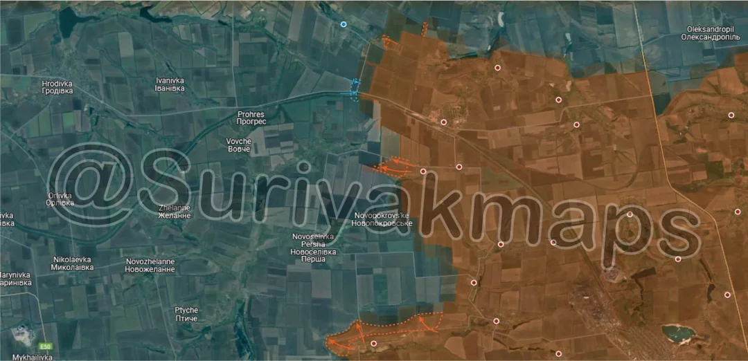
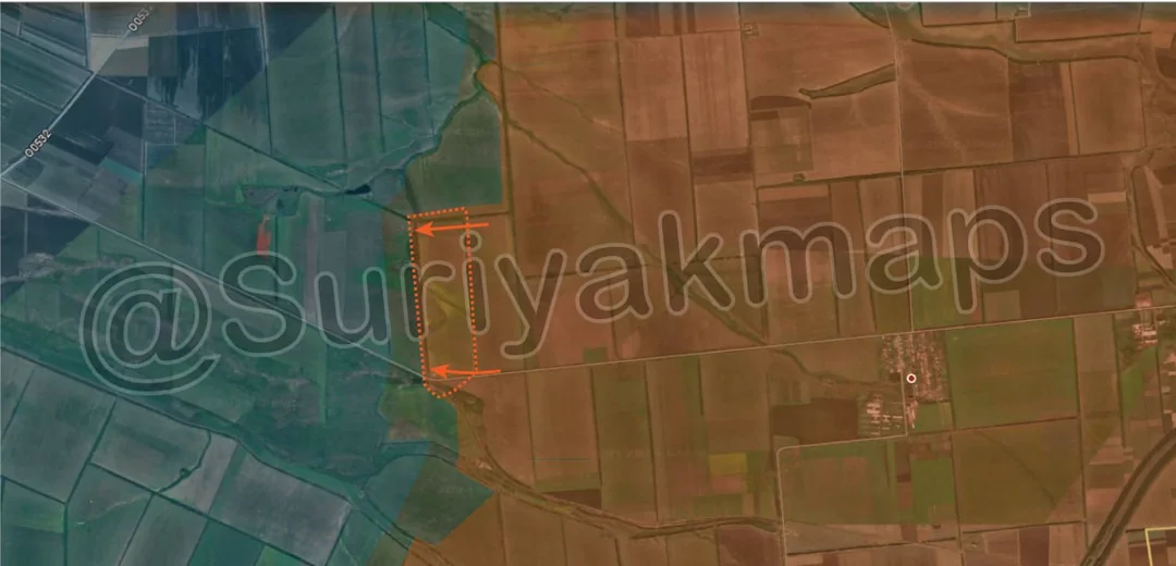
Back home
Post #39

RU POV: Russian and Ukrainian advances on Day 822 and 823 of the war - Suriyakmaps

May 26, 2024 — May 27, 2024 War Day 822–823

Sorry I am late with this. Had a lot going on and Suriyak also didn't post for one day so I've only got to it now.

Pics 1 and 2 are from Day 822, Pics 3 to 8 are from Day 823.

A reminder that these maps are confirming updates from yesterday (i.e. 12 to 24 hours delayed).

Ukrainian Advance
1.40 km²
Overall (set): 1.40 km²
Russian Advance
12.53 km²
Net Change
-11.13 km²

Situation Snapshots

Imagery, commentary, and territorial changes from the period.

8 entries
Russian Forces Advance: 1.39 km²

Advance = 1.39km2

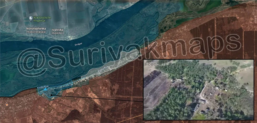
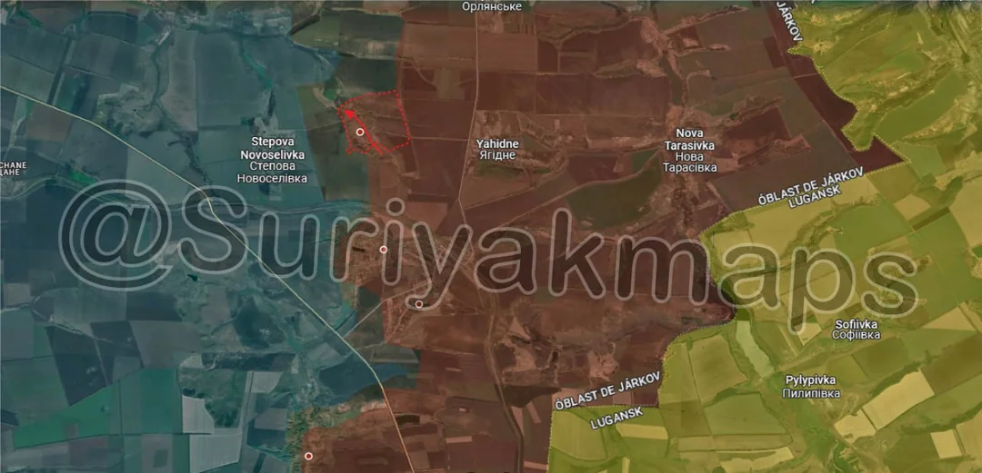
Following on from what I said in my previous post, Russian forces captured the village of Ivanivka quite quickly. This was entirely expected, as the village is very small, sits lower than the (Russian controlled) surrounding terrain, and was relatively exposed with only 1 supply road. From here, Russian forces will likely start moving west towards the next village of Stepova Novoselivka.
Russian Forces Advance: 1.15 km²

Advance = 1.15km2

Following the alleged withdrawal of Ukrainian forces from Krynky, geolocated footage has shown Ukraine now occupy positions in the neighbouring village of Kozachi Laheri. To both remind you and explain how this occurred, Russian forces do not actually occupy the territory along the Dnieper river, but sit in positions further inland. This both protects them from FPV drone attacks launched from the other side of the river (out of range), but means it is relatively easy for Ukrainian forces to occupy new areas immediately along the river's edge. Whether this is the same force that was in Krynky, or a different one that crossed the river, is yet to be determined.

To put it bluntly, Ukraine's insistence on continuing operations on the left bank of the Dnieper is....baffling. Krynky can only be considered a colossal failure that did not meet any of its alleged objectives, was launched too late to make a difference to the counteroffensive, and ended up harming Ukraine more than simply sitting on the other side of the river doing nothing would have. Why Ukraine would then insist upon keeping a presence here, even if only a few hundred metres west, when they are having severe manpower issues, is unknown.

Russia has yet to 'recapture' Krynky, so the battle is not technically over yet, and the village remains in the grey zone.
Russian Forces Advance: 2.96 km²

Top Advance = 0.97km2, Bottom Advance = 1.99km2

Adding onto the capture of Ivanivka in picture 1, Russian forces pushed west from Kyslivka, as well as capturing more of Berestove. There are technically still a couple of buildings not under Russian control, but given they are less than 200m away from their current positions, and in the greyzone, it is safe to say Russia has captured the village.

The capture of Berestove is relatively important, as there are no settlements between it and Kruhlyakivka (on the Oskil River). This means Russian forces have the potential to make larger advances in the open fields towards the river.
Russian Forces Advance: 1.87 km²

Top Advance = 1.19km2, Bottom Advance = 0.68km2

Moving just south of picture 3, Russian forces have recently become active along this area of the front, taking over some trenches east of Miasozharivka (blue dot top of picture), and some forested area west of Novovodyane (red dot, bottom right). The northern advance is the more interesting one, as it has greatly expanded the greyzone, and indicates Russia is pushing to cross the Zherebets River.
Russian Forces Advance: 0.62 km²

Advance = 0.62km2

Following smaller skirmishes and positional battles, as seen in this video, Russian forces have captured more of the ruins of Bilohorivka. Whilst Russia has not captured the whole of the town, this advance in the centre threatens Ukrainian positions in the north, including the recent small advances they are made, as there is now only a small hilly area connecting it to the main Ukrainian positions. Russian will likely continue trying to capture the rest of the town, but will have difficulty due to strong Ukrainian positions on the chalk quarry and western hills.
Russian Forces Advance: 4.39 km²

Top Left Advance = 0.10km2, Top Right Advance = 0.09km2, Upper middle advance = 0.25km2, Middle Advance = 0.84km2, Bottom Advance = 3.11km2

Following Russian troop rotations which have taken place over the past 2 weeks (to swap out the forces involved in taking Ocheretyne and surrounding areas), Russian forces have become much more active.

North of Ocheretyne, Russia has captured more treelines, looking to position themselves for assaults on Novooleksandrivka and, eventually, Kalynove. Ukrainian forces were able to slightly push Russia back along the railway, however further south Russia has managed to push closer to Sokil, undoing Ukrainian counterattacks.

As I mentioned in this comment, with the fall of Umanske Russia was likely to capture the surrounding fields within a few days, up to the small stream and reservoir, which has now occurred today. Russian forces here will likely focus on advancing towards Yasnobrodivka (just south of map), and the remaining fields north of Umanske.
Ukrainian Forces Advance: 1.40 km²

Advance = 1.40km2

West of Solodke, Russian forces made an opportunistic advance, taking over another large field, and inching closer to the O0532 road.
Russian Forces Advance: 0.15 km²

Advance = 0.15km2

Russian forces made a small advance in Urozhaine, but have been unable to advance further north so far due to a lack of forces, and dense Ukrainian minefields. Ukrainian forces in Staromaiorske are not having the same luck, being forced to withdraw from most of the town due to intense Russian shelling.

If Russia is able to capture Staromaiorske, Ukraine will almost certainly be forced to retreat from Urozhaine, despite their strong position, due to the threat of being attacked from the side and rear if Russia crosses the river.